Map
Full List
.csv file

Mount Marsden

NameElevation (metres)Prominence (metres)Points
Mount Bindo
1362
433
7
Bonfire Hill
1296
226
7
Mount Tarana
1275
282
7
Mount Coricudgy
1258
588
7
Mount Coriaday *
1231
321
9
Mount Walker
1187
241
8
Dulabree *
1183
151
4
Mount Wilworril *
1179
306
9
Mount Cloudmaker
1163
389
8
Tayan Pic
1156
370
10
Marrangaroo
1148
161
4
Mount Durambang
1145
359
8
Mount Never Never *
1143
266
8
Mount Midderula *
1142
217
8
Mount Monundilla *
1119
384
8
Mount Kelgoola *
1116
226
8
Evans Crown
1103
177
5
Mount Pomany *
1100
348
8
Bin Ben
1095
285
9
Mount Stromlo *
1088
155
4
Mount Darcy
1082
227
6
Kekeelbon Mountains
1080
186
6
Mount Cox *
1074
183
6
Mount Coorongooba
1072
206
7
Baldy Peak *
1070
308
6
Black Ridge
1064
184
4
Jews Mountain *
1061
183
4
Mount Banks
1059
196
6
Wheelbarrow Mountain *
1054
316
7
Mount Colong *
1045
243
7
Genowlan
1038
294
6
Mount Airly
1036
245
5
Fitzgerald Mount *
1033
183
7
McDonalds Mountain
1032
191
6
Church Mountain
1024
158
4
Mount Tomah
1020
175
3
Mount Marsden
1019
261
7
Brymair *
1019
191
6
Pantoneys Crown *
1017
324
8
*
1016
175
6
Blackmans Crown
1012
189
5
Mount Touwouwan
1010
234
7
Wongalee *
996
209
6
Donkey Mountain *
993
334
8
Above Newnes *
987
191
5
Haystack Mountain *
986
229
7
Bluff Mountain *
980
158
3
Teatree *
971
206
4
Mount Towinhingy
965
178
6
Mount Warrigal
964
294
6
Beer Bung *
964
170
3
Mount Solitary
959
311
6
Dairy Mountain *
952
168
5
Razorback *
951
168
5
Spring Log Ridge
947
190
5
Mount Coolcalwin *
945
229
7
Pipeline
937
187
4
Baker Ridge *
914
183
4
Mount Bathurst *
905
150
2
Coxs Crown *
890
157
5
Donkey Junior *
881
207
6
Yerranderie Peak *
872
191
6
Mount Brace *
871
195
6
Tonalli Mountain *
870
201
4
Mini Mini Range
869
167
3
Cottage Rock *
866
186
3
Mount Remorseless *
865
260
5
Tebradden *
857
174
3
Mootick Plateau *
848
151
1
Gunyawarilda *
845
215
4
Gundangaroo *
844
381
6
Elyl Peak *
841
176
2
Lords Mountain *
839
202
4
The Sentinels *
839
158
4
New Yards Hill *
839
158
1
Mount Jellore
835
190
6
Carlyon *
821
175
2
North of Glen Davis *
815
199
3
Green Hill *
813
163
1
Ironpot Ridge
804
206
4
Bull Island Peak *
804
200
6
Mount Alexandra
794
162
3
Perry *
772
153
1
Wollemi *
767
181
1
Broken Rock Mountain *
762
331
4
Green Wattle Mountain *
744
266
5
Torbanite Mountain *
729
233
5
Mount Milo *
727
155
3
Martindale
695
286
4
Flat Top Mountain
687
165
3
Mount Carrialoo
686
215
4
Mount Yengo *
667
365
6
Mount Neilson
661
321
6
Mount Warrawolong
639
403
7
Mount Skanzi
622
271
5
Popes Creek *
613
211
5
Mount Moollattoo
605
186
4
Mount Wareng
594
265
6
Broughton Head *
578
196
3
Mount Cookem *
573
239
3
Mount Poppong
573
212
4
Doyles Range *
569
156
0
Mount Isobel
553
207
3
Island
544
193
5
Culoul Creek
541
188
1
Mount Kembla
534
209
5
Mellong
518
192
1
Bridgeview Farm *
503
205
2
Parr South
502
159
3

Elevation1019 metres
Prominence261 metres
Location-32.9321, 150.0494
RegionNorth-West
Points7

Download GPX file

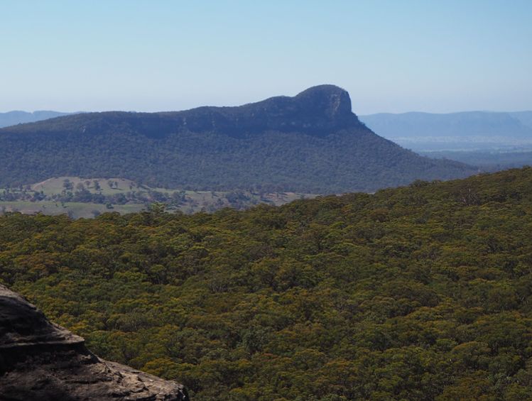
A mighty wall of solid rock at the north end of the Capertee Valley. Mount Marsden dominates the surrounding landscape. The walk up Mount Marsden is strenuous but rewarding. Allow about 4 hours for the return journey.

Driving directions

From Kandos, drive east then south along Glen Alice Road. As you drive south you will see Mount Marsden rising on your left. After 10km the road enters Kandos State Forest. Pull over to the side of the road.

Directions to the summit

1. Leave your car and walk east into the forest and down into a steep grassy gully.

2. Cross the gully and begin climbing up a spur. The climb is very steep and just goes straight up to the top.

3. At the top, turn right and walk south along the top of the escarpment. The going is very easy, being mostly flat open woodland without undergrowth. There are great views across the valley to the west.

4. Eventually you will come to the Pagodas. These are giant rock formations, the size of buildings. They are well worth an explore, but if you want the quickest way to the summit, skirt around to the east (away from the cliffs) and follow the back of the rocks till the land rises sharply and you have to start climbing again.

5. There is a "false summit" 300m before the actual summit. This has possibly the best views of the whole walk.

6. The actual summit is in a grassy woodland.

7. The views are found 100m away at the south-west corner. The route back is along the same path you took to get to the summit.